Strong cold front due Thursday night, bringing the coolest air of the fall
Showers are possible ahead of it. Behind it, lows in the 60s on the islands, highs in the mid-70s and gusty north winds Saturday, the Weather Service says.
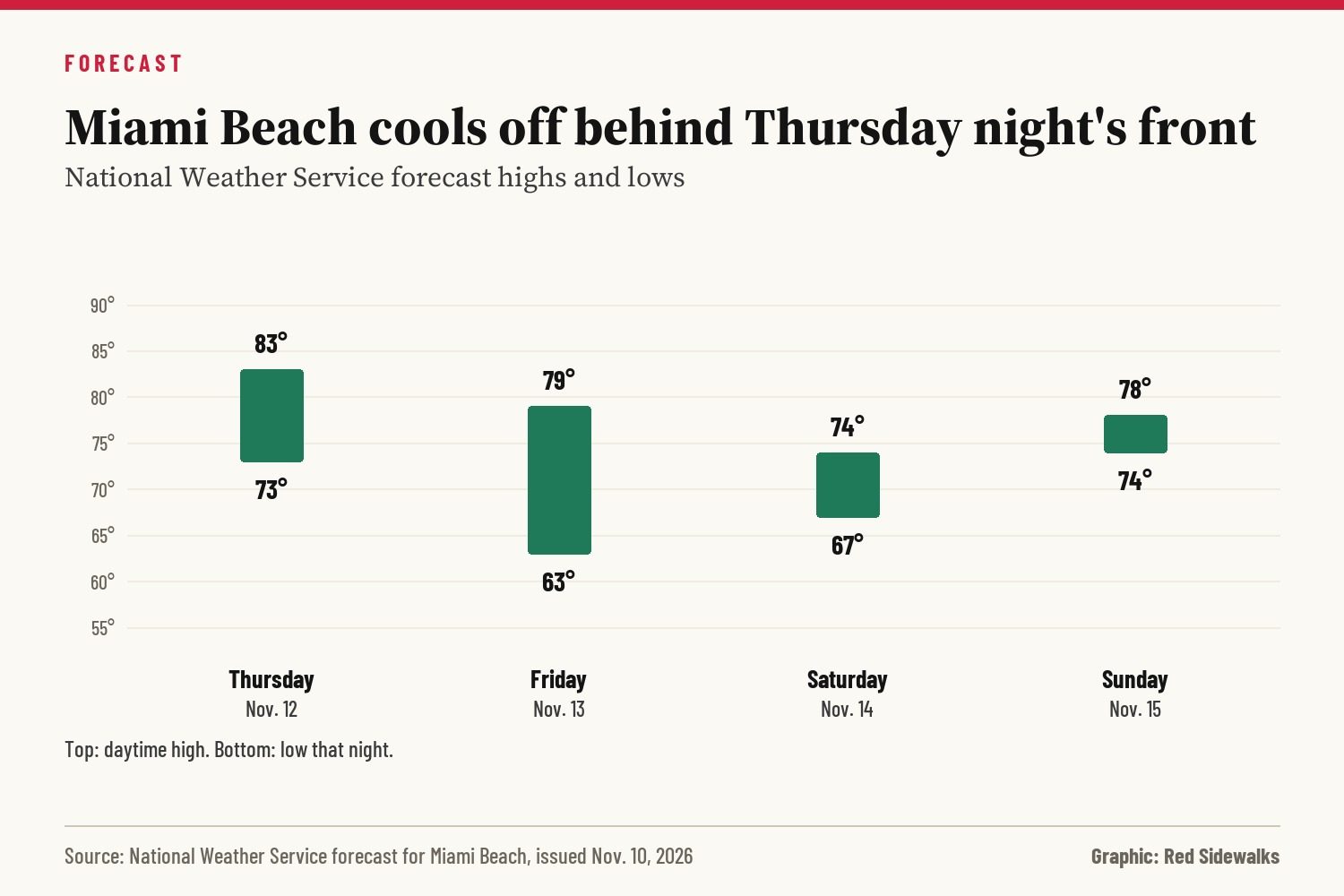
A strong cold front is expected to push through South Florida late Thursday night into early Friday morning, the National Weather Service in Miami said Tuesday, and the air behind it will be the coolest of the fall so far.
Before it arrives, scattered showers and a few thunderstorms are possible from Wednesday afternoon through Thursday night, with a 20% to 40% chance of rain on the islands, according to the forecast for Miami Beach. Winds turn southwest Thursday and could be breezy and gusty. Forecasters said the front now looks likely to move through faster, which would keep showers scattered and the chance of storms low.
After the front passes, the forecast for Miami Beach calls for:
- Friday, Nov. 13: mostly cloudy, with a high near 79 and northwest winds around 10 mph.
- Friday night: a low around 63, with northwest winds of 12 to 18 mph.
- Saturday, Nov. 14: sunny, with a high near 74 and north winds of 13 to 18 mph.
- Saturday night: a low around 67.
- Sunday, Nov. 15: mostly sunny, with a high near 78 as winds turn northeast.
Inland areas will be cooler. Lows could drop into the 50s across most of South Florida on Friday and Saturday nights, the Weather Service said, and highs Saturday may stay in the upper 60s along and north of Alligator Alley.
On the water, seas will stay at 2 feet or less through midweek, but hazardous conditions may develop in the Atlantic and Gulf late in the week as winds and seas build behind the front, forecasters said. The rip current risk at Miami-Dade beaches was low as of Tuesday afternoon. No watches, warnings or advisories were in effect for the area Tuesday evening.
Live beach cams are at redsidewalks.com/cams.
Sources
See something wrong? Tell us.
Neighbors' comments
Comments are for people who live in Miami Beach, Surfside, Bal Harbour, Bay Harbor Islands, North Bay Village or Sunny Isles Beach. Keep it civil and on topic; the editor reviews first comments.